digital mapping
Grave mapping: Why Now is the Time to Choose Digital Cemetery Maps
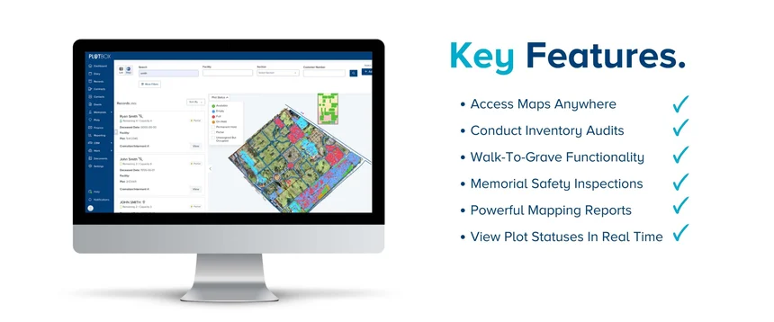
Discover just a few of the benefits of enhancing your grave mapping with digital cemetery maps linked to deceased records.
Discover precise cemetery mapping with our state-of-the-art software, powered by high-res drone imagery for mosaics accurate within 1-3 inches. Step into the future of cemetery management.
Personalised mapping services for transforming cemeteries. Digitise old maps, import your current Excel data, and get customised solutions to meet your needs.
Streamline inventory management with our cutting-edge technology. Our real-time forensic audit will help maintain your inventory with precision and efficiency.
Unlock your cemetery's potential with our digital mapping solution. Enhance workflows, efficiency, and communication.Identify risks in real time.
Like To Learn More?
Complete our form for a downloadable mapping eBook

Discover just a few of the benefits of enhancing your grave mapping with digital cemetery maps linked to deceased records.
Unlock precision and efficiency with 'True' Digital Cemetery Mapping. Elevate operations, reduce errors, and enhance revenue generation.
Discover the benefits of cemetery software and GIS mapping for inventory management. Improve visibility, eliminate risk, and streamline sales...
The mapping software is designed to transform cemeteries by providing a detailed mosaic of the site using high-resolution imagery captured by drone technology. It offers a 360-degree view of the cemetery, allowing users to explore immersive mausolea and columbaria mapping options for a comprehensive understanding of the facilities.
The mapping software boasts an impressive accuracy of 1-3 inches. This high level of precision ensures that the detailed mosaic created by the software provides an accurate representation of the cemetery.
The drone technology utilised by our software captures high-resolution imagery of the cemetery. These drones are equipped with advanced cameras that capture aerial shots of the site from various angles, allowing for comprehensive coverage and detailed mapping.
By using our mapping software, cemetery owners and managers can gain unparalleled insight into their facilities. They can explore the cemetery in a 360-degree view, analyse immersive mausolea and columbaria mapping options, and understand the layout and organization of the site like never before. This software enables better planning, decision-making, and management of the cemetery.
Absolutely! Our mapping software is designed with ease of use in mind. It offers a user-friendly interface that allows cemetery owners and managers to navigate and explore the cemetery effortlessly. The intuitive controls and interactive features make it accessible to users with varying levels of technical expertise.